
It took me 54 years; but on Saturday I went to St Kilda. It was worth the wait. Well worth it. What an amazing place. For those who are not familiar, St Kilda is the most remote outpost of Britain. It is a small but spectacular archipelago in the Atlantic, some 40 miles north-west of North Uist in the Outer Hebrides. Hard though it is to imagine, the largest island, Hirta, was occupied by a small number of humans (probably no more than 180 at most) for upwards of 2,000 years. That ended in 1930, when the last 36 occupants applied to the government to evacuate to the mainland. Life simply got too hard for those still there. Their story is well documented, taking place in an age of film and photography. But when you stand there, even on a lovely warm, sunny, calm day like we enjoyed, you just can’t imagine what kind of a life that must have been.
I had noticed with some excitement that the Ordnance Survey had included St Kilda in a box in the corner of map 18. This gave me the excuse I had always needed. It was neither cheap nor easy to get a place on one of the small boats that make the journey out there; but if not now, then when? It would be a great way to bring my first month of this adventure to a close. That is why I made such an effort crossing Skye, which we will see again in future maps, to have a chance, weather permitting, of fulfilling a life ambition. The trips often don’t go. It is a notoriously hard place to reach. The inhabitants had to get by without outside help. Given the variety of weather I had experienced on my trip so far, especially the strong winds, I had my expectations set at hopeful realism. To increase chances of success, the boat companies operate on 2 day windows, so if you cannot sail on day 1, at least you get a second chance. And that is what happened in my case, which suited me, because I needed a day off first!
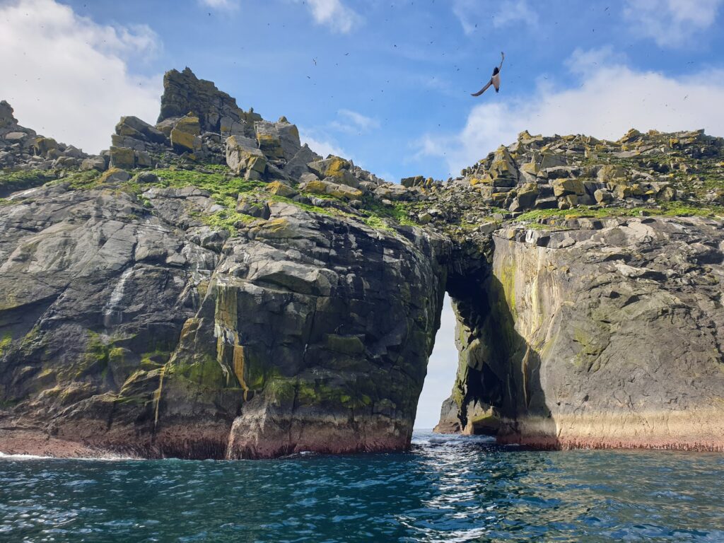
We met at the jetty at Stein, on the Waternish peninsula, at 6.45am. I was staying nearby, so the cycle in was only about 10 mins, thank goodness. I am, after all, allergic to mornings, and I knew this would be a very long day. The journey out there in our 12 passenger, 2 crew boat took 4 hours. I was worried about the possibility of sea sickness. Sure enough, an hour or so into the voyage we move out of the sheltered waters of the Minch and cleared the bottom of Harris and out into the Atlantic proper. Suddenly it got exciting. The little boat was tossed about and slapped into waves as it moved further out. No one seemed unduly unsettled; but you wanted to hold on to the back of the seat in front. It was actually quite fun once you got used to it. After a long time, an improbable green cone of land appeared over the far horizon, turning into 2 distinct islands as we got closer. The smaller and more northerly, Boreray, where we headed first, is uninhabited and probably uninhabitable. Unless, that is, you are a seabird, in which case it is THE place to live in Europe. Both main islands have astonishingly high, vertical sea cliffs and sea stacks, the highest in the UK, and this vertical world absolutely teems with bird life.
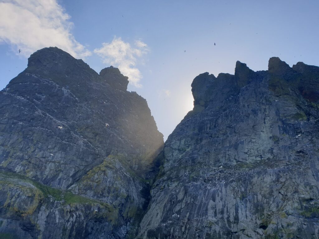
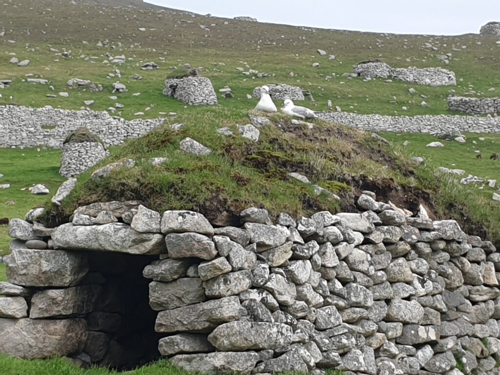
There are countless nesting pairs of gannets, puffins, fulmars, guillemots, razorbills, shags, kittiwakes, petrels and more, numbering above a million birds at the height of the breeding season. It is a frenzy of activity and noise, which we had the privilege to sail right underneath, the gannets wheeling around above our heads as we bobbed around at the foot of the towering cliffs. It was the presence of so many sea birds that made human existence in St Kilda sustainable, if incredibly hard. Every year, the able bodied men would lower themselves over the cliff edges on ropes of horse hair and harvest many thousands of birds and their eggs. The harvest was equally shared among the population. It would provide their main source of food for the the year: plucked, dried and cured before being stored in one of the 300 or so stone “cleits”, igloo-like shelters with turf roofs and dry stone walls, still scattered around the islands. The birds also provided oil and feathers that could be traded and used to pay rent. It was unimaginable to me what it must have taken to land a rowing boat from Hirta on the sheer, wet rock of Boreray, let alone the skills required to get anywhere near the nesting birds with their sharp beaks. But they reached and took them it in vast numbers, year after year, for as long as the human population remained.
As is so often the case with isolated communities, it was external influences that most ravaged the local population. Visiting ships brought smallpox and cholera, and zealous missionaries brought religion that took such a hold as to compromise the time available for work. This apart, the inhabitants knew little of the outside world, and could communicate only by lighting a bonfire in good weather at the top of the highest hill, Conachair, which might be seen on Harris or North Uist. Mailbags containing messages would be cast into the sea and could often be found washed up anywhere from the Scottish mainland to Norway, some time later.
Contact increased in the 20th century and the islands became a military outpost in WW1, with regular food deliveries. When these ended, many of the young men left the islands. Coupled with repeated crop failures, life became less sustainable, leading to the collective decision to evacuate in 1930. The last of the native St Kildans died in 2014 aged 93.
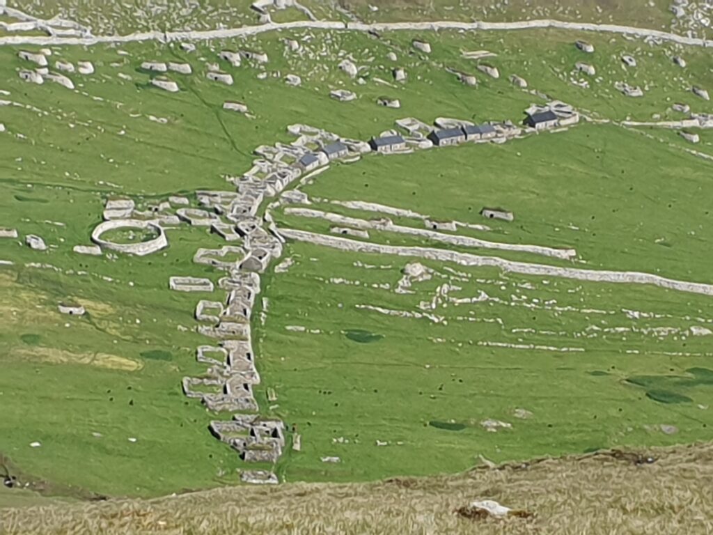
Today St Kilda has double World Heritage Status, for both natural and cultural significance, the only such example in the UK. It is the most important seabird colony in Europe. We landed in the shelter of the circular Village Bay and had 4 hours on Hirta, wandering among the ruins of houses and cleitian and climbing up to the highest point on Conachair for the remarkable panoramic view of the islands and stacks. It was a glorious day to see the twisted volcanic landscape, all that remains today of a huge caldera. It is a more vertical than horizontal place, with little flat ground. The islands play host to herds of completely wild Boreray and Soay sheep, who are the subject of an ongoing scientific study. They are considered to be very rare examples of primitive neolithic and iron age sheep. The lambs were everywhere to be seen, looking much cuter than their parents, whose fleece was moulting in chunks, giving them an unkempt appearance.
There cannot be many more beautiful, extreme, sad or uplifting places anywhere. It was a remarkable day. We arrived back on Skye around 7.45pm and I cycled back the long way by skirting the very end of the Waternish peninsula. On a day of going to the very limit of human habitation, it felt like the right thing to do!
5 replies on “Map 18 – St Kilda”
Wow. What a day!
We have all been following your journey Mark, this sounds like the most fascinating day yet!!
It was a pretty awesome day Andy. You must go one day.
Incredible description of a unique phenomenon – hats off to you, Mark, for following through on that lifetime ambition and documenting it in such an engaging way. Loved the description of the seabirds noise as the boat bobbed at the foot of the cliffs. Safe journey home from the end of month 1!
Thanks Penny. I made it home and I’m enjoying the comforts for a few days while I plan the next month! After a month of everything running to a smooth plan (ish), I have NOTHING arranged at all – and I leave again in 6 days! Work to do….