
When Douglas Adams told us the meaning of life, the universe and everything was 42, I am willing to bet he had never cycled the B887 between Tarbert and Huisinis, on the Isle of Harris, on a gorgeous evening. Since we sadly can’t ask him any longer, I am going to assume I’m right. Because if he had, he would have surely mentioned it. It’s fair to say that it ranks among the best roads I have ever cycled. And that, if I say so myself, is saying something.
The day began in a much less auspicious way with interchanging periods of grey and rain in Stornoway. Every time you thought the rain was finally finished, it came back, as if it had forgotten something. I sought refuge back at the Hub bike shop and cafe, borrowed their track pump again, and savoured one of their excellent lattes. I was really killing time until the 12.30pm bus to Tarbert, 36 miles away. I was quite within my rights to use any available transport in this direction. But first, leaving my pannier at the Hub, I cycled out a few miles to a memorial to a group of men who found themselves landless after suffering much in WW1. Despite threats of legal action, in 1921 they took possession of land at Upper Coll from which their families had previously been evicted. Their ancestors benefit from their action to this day. The level of oppression suffered here by common people almost within living memory is breathtaking.
I also had time to visit the grounds of Lews Castle (correct spelling) which face the town prettily across the harbour. It makes for a really pleasant recreational area for the townspeople of Stornoway, and is being given a facelift. The building itself, a Victorian mock castle, was built by Sir James Matheson, who made his fortune from the opium trade. It, along with the whole island, was bought by industrialist and philanthropist Lord Leverhulme in 1918. Now it is set up to host posh events, based on what I saw through its windows. Part of it is also the free to enter museum (closed Mondays unfortunately) in which you can see 6 of the original 12th century Lewis chessmen on display, discovered on the island in 1831. I’ve seen others from the hoard, made from walrus ivory, in the Museum of Scotland in Edinburgh. They are amazing.
The bus (a coach) took my bike the hour’s drive to Tarbert. Sometime on the way, about where the mountains began, we left Lewis and entered Harris. It stopped raining at about the same point. Coincidence? The divide is indistinct here. It is all the same island; but has 2 quite different identities. You don’t pass through much on the way from one to the other, making Tarbert, the “capital” of Harris, feel quite big when you get there, which it isn’t. Its name means isthmus in Gaelic, and it sits on bays facing both east and west, separated by not much more than the grounds of its modern new school. If you had a catapult, you could literally propel a Cadbury’s Creme Egg from one coast to the other. Probably. That is all that joins together North and South Harris, a much more obvious place for Lewis to end, you’d think, if you couldn’t agree on a single name for one big island.
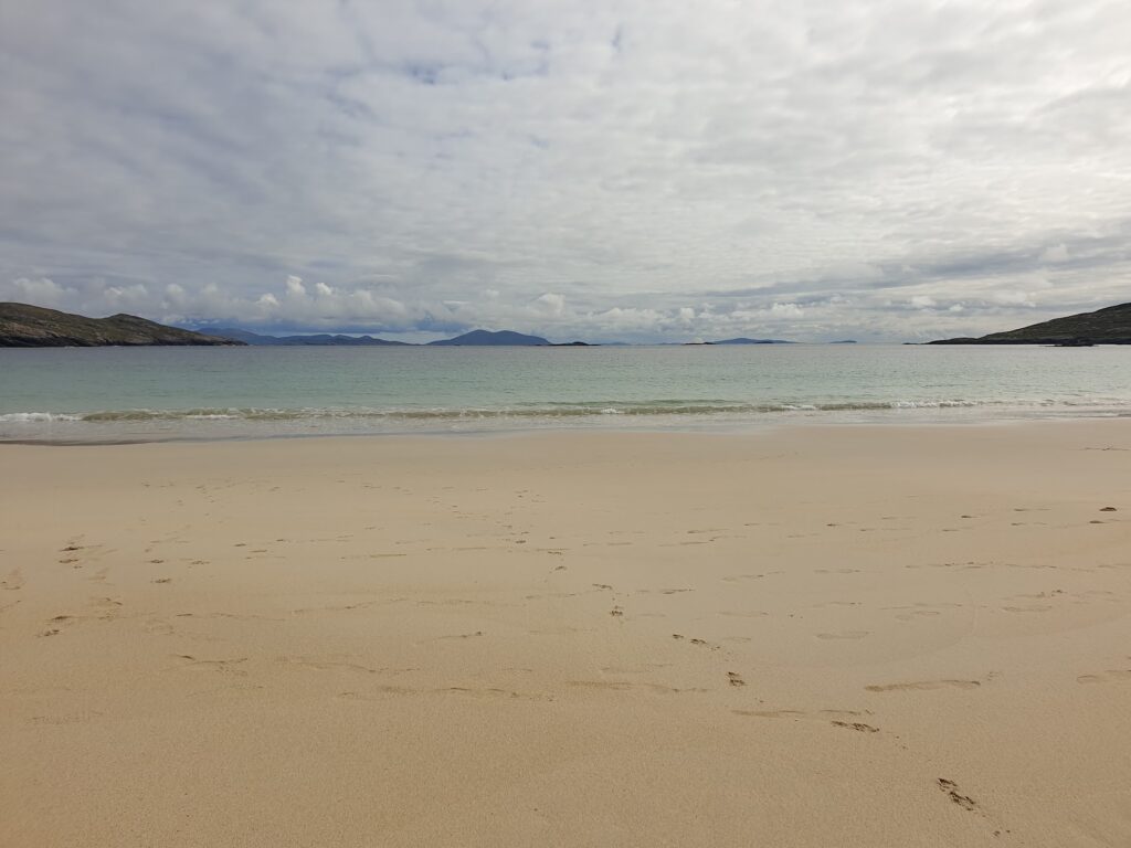
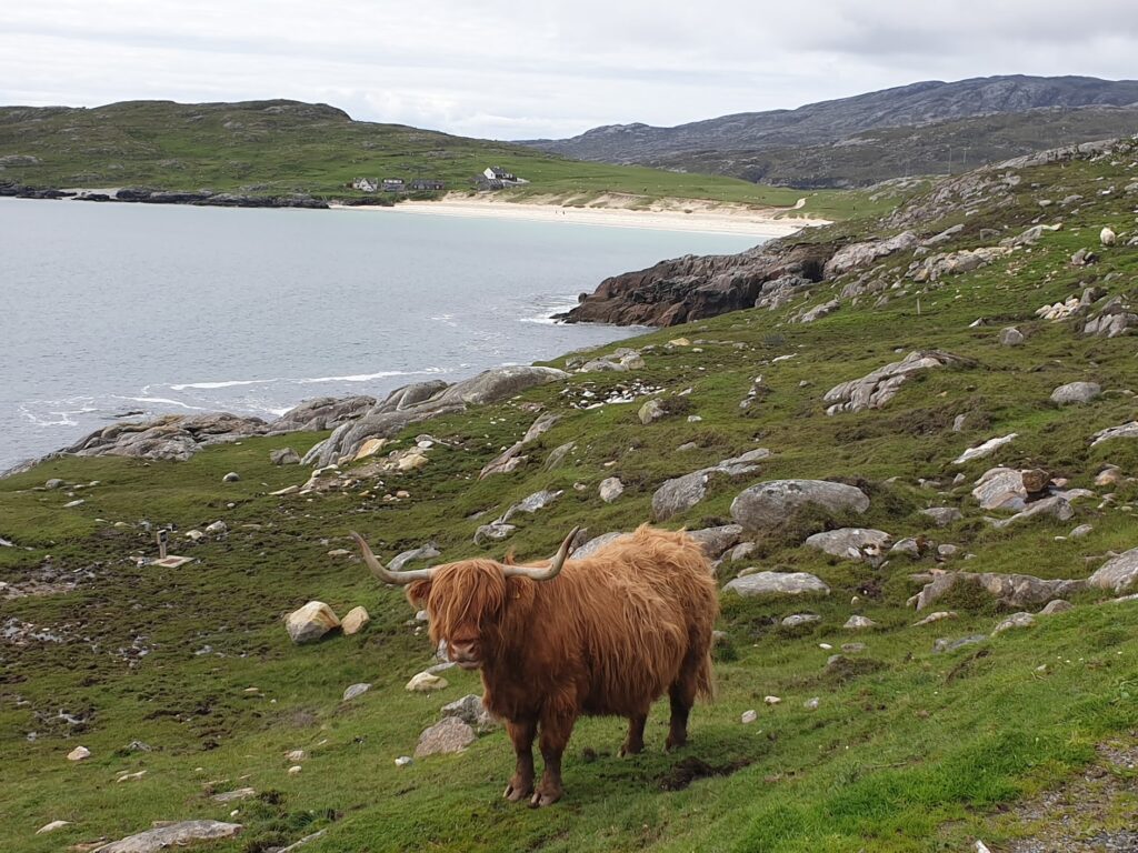
The weather in Harris was much better. I got some lunch at the Hotel Hebrides where I am staying tonight, dropped off my bag, and headed straight out for the most westerly road head on OS map 13. Which brings me back to the diminutive B887. This thin ribbon of tarmac roller-coasters its way along the northern edge of Loch A Siar, All the way it hugs the rocky slopes of the North Harris mountains for 14 miles until it comes to a full stop at the jaw-droppingly beautiful, south facing Bagh Huisinis, with its white sand beach and turquoise waters. It is just wide enough for a single car, so even the presence of a bike calls for the use of one of the regular passing places. But for most of the time it is all yours. Traffic is very light even on a gorgeous May afternoon like today. The views are to die for: that winning combination of big mountains and sea, with lots of small islands for added interest. The hillsides were mostly bare rock. There is nothing soft or gentle about this landscape. It is “don’t mess with me” hard. A few sheep graze the slopes, running freely across the road as the mood takes them; but nothing much grows here. The road takes a tortuous route wherever the mountains will allow, passing waterfalls and lonely cottages with breath-taking views.
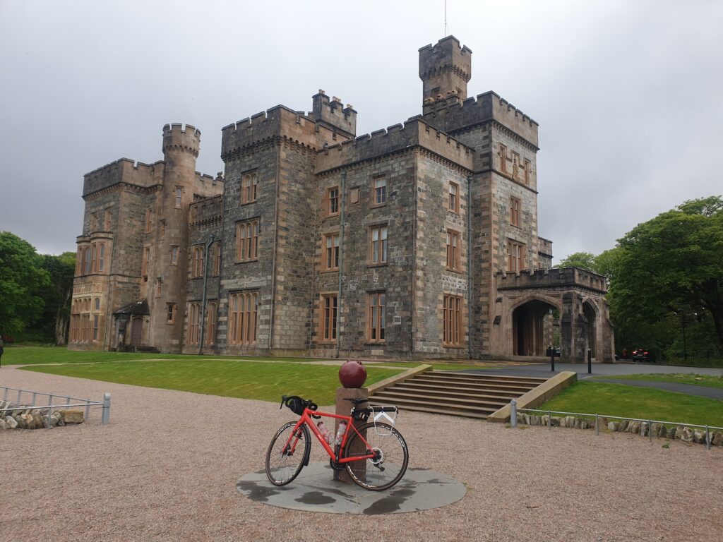
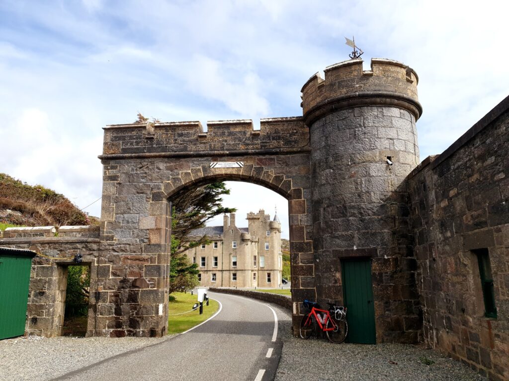
You just get used to all this hard-edged beauty when, suddenly around a corner, everything abruptly changes. I’d been told yesterday about a special place here by Richard on the train. “You enter Telly Tubby land”, he said in all seriousness. “There are rabbits and unicorns and smiling babies.” Not quite; but almost. I knew what he meant. A stream flowing down from Clisham, the highest mountain, went under the road and then squeezed through a narrow slot between huge boulders. It emerged in a broad cascade that fell down into a secluded, manicured bay, the grass as green as could be, forming the lawns in front of a fairy tale Scottish country castle, complete with turrets and archway over the road. It really was a pinch yourself moment. I had arrived in the grounds of Abhainn Suidhe Castle, along with its attendant estate village, an amazing and unlikely world within a world. Apparently it is now a 5 star hotel, offering up to 18 guests exclusive use of the castle, fully staffed and catered, including a resident team of ghillies and stalkers. Venison was for sale in the stable.
Returning to the real world, I cycled to the end. Just above the glorious beach were a couple of camper vans and a herd of highland cows looking on in disdain. I felt that just about every box had been ticked for my starting point on OS map 13. I went down to the beach and chatted to a swimmer in a wetsuit. Everyone there looked serene. Then I remembered my dinner reservation and decided I needed to start the long journey back to Tarbert, which I basically did all in one go, having already made stops for photos and conversations on the way out.
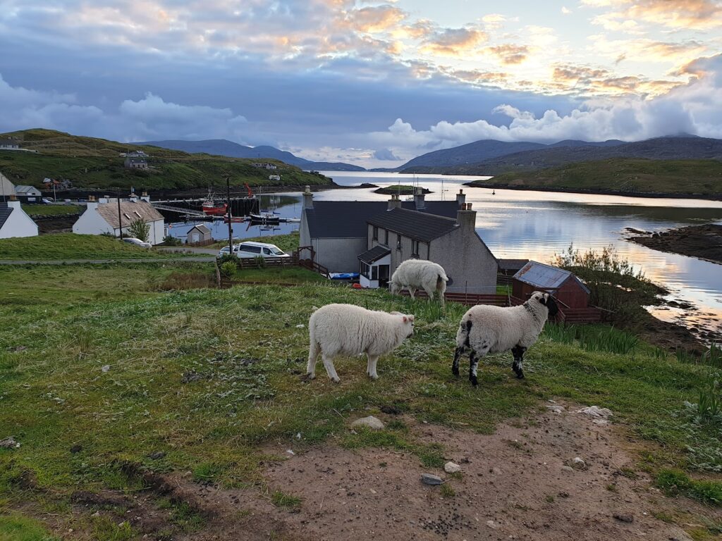
As it was such a glorious evening, I felt it could not be wasted. So after a shower, dinner and a pint of Skye Red ale, I changed back into cycling clothes and took off on the curiously signed C37 road east towards the island and village of Scalpay. This is linked to Harris by a modern, single arch bridge that spans the strait between the islands. The hotel manager seemed to think I was a bit strange heading out at this time, although the sun was still quite high in the sky at 8.45pm. “That road is a wee bit up and down” he told me. It was an understatement; but after a pint of beer I often find I have renewed energy. Or maybe it was the lamb tagine. Either way, the scenery was every bit as good as the earlier ride west. It was the calmest of evenings and the road, which was surprisingly wide, afforded sweeping views down over Scalpay and beyond to the mountains of Skye on the far horizon, glowing in the late sunshine. The sea was like a millpond and it was studded with countless islets. The only sounds were the bleating lambs and the cuckoos. It all felt idyllic. Of course, life here has always been hard, especially in the dark winters; but to this long distance adventure cyclist it was about as close to perfect as it gets.
And now I have not only the problem of how to better that in the rest of the trip; but also the dilemma of what to do tomorrow. I need to reach Stornoway to stay overnight and catch the 7am ferry on Wednesday. But that is in map 8. The next map in my sequence is map 14, which overlaps most of the southern half of map 13. The purpose of my journey is to link all of the maps together in numerical order. To see more of map 14 than the few miles I saw this evening (getting to Scalpay and back), my adventure would have to take me south onto the “Golden Road” to South Harris. If I ride straight back towards Stornoway, I will cross more of map 13; but then join on to map 8. I probably wont have time, energy or good enough weather to do both. I can leave my bag here if I head south and come back. The road to Stornoway, on the other hand, heads north up a mighty long and steep climb past Clisham, before crossing long featureless bogs. I am tempted to let the bus take the strain, especially since the forecast for Stornoway tomorrow afternoon is – you guessed it – rain. Like Boris Johnson, I’m not so attached to any of my own rules that they can’t be broken. Unlike Boris, I shall always do what seems right at the time. I suspect you already have your own thoughts about what I might choose.
2 replies on “Map 13 – Huisinis Heaven”
You have made me sad that I left when I did. Sounds glorious. One day you will have to take me back.
Another lovely days riding and writing! I’m enjoying my daily dose. I suspect the bus is the right answer.