
After yesterday’s good weather and memorable cycling, it was a disappointment to see heavy rain start in Tarbert around breakfast time this morning. I was really hoping for better. Still, things have a habit of working out. I thought final checkout was 10am; but they told me it was actually 11am, so I went back to my room and dosed for an hour. When I checked out, the rain had stopped.
By the way, before anyone says anything, I know I have put Map 13 on Instagram. It should have been there yesterday, of course; but I had too many other pictures and I was tired. However, since this is my permitted “new map for the month”, bought on a Calmac ferry specially for the trip, I have popped it in here as a segue between maps 13 and 14, which belong together, as they overlap and between them cover most of Harris. It also has a nice picture on the front.
The big Calmac ferry from Uig in Skye was unloading as I left the hotel. For several days this route had been out of operation due to some problem with the boat. The Calmac fleet is ageing and 2 new ships, commissioned by the Scottish government, stand unfinished in a Glasgow shipyard, embroiled in controversy and wasted public money. So the service is under strain and subject to interruption. When we sailed back to Ullapool a week ago, we met a couple of cyclists whose car was stranded on Skye. They had been brought back via Stornoway and would now be taken at Calmac’s expense on the 135 mile road journey to collect it, before driving themselves back the way they had just come on another 150 mile journey home to Forres! They were hoping to get home by midnight. At least they would be mostly in the daylight.
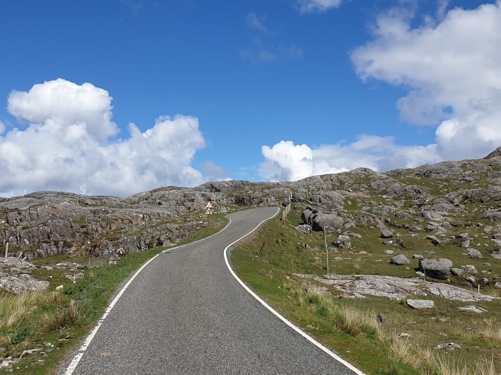
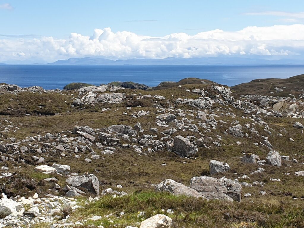
After I left Tarbert, it just kept getting better. I had decided to cycle the so-called Golden Road to the bottom of Harris, almost all of which is exclusive to OS map 14. This road is fewer miles than the main road, which follows the west coast; but it is tiny and it winds its way through all kinds of small, isolated communities, many of which seem to be surrounded on all sides by water. As well as the many sea inlets in this fractured coastline, the flatter spaces between the bare rocks are mostly taken up with attractive fresh water lakes and ponds. Often you would find yourself looking down over water at one level to the sea lower down, in a kind of blue staircase effect. The hilly road joins together places that are rarely much more than a few houses. You might see the odd chapel, a small harbour or jetty, and the occasional art gallery or weaving workshop. If you wanted refreshment or groceries, you were out of luck. All the way there were gorgeous views across the Minch to the mountains of Skye. The huge sky above was mostly blue, with a scattering of different coloured clouds, a reminder that rain could never be discounted. There was the odd light shower, but hardly worth mentioning. By the time I reached Roghadal, at the bottom tip of Harris, a mile or two off the bottom of the map, the sun was shining warmly and brightly, and everywhere was bright and colourful. The views in all directions were compelling: out to sea, the islands of Skye and North Uist, as well as countless smaller islets, and inland the mighty, bare mountains, covered from head to foot in Lewisian Gneiss, some of the oldest rock in the world at a cool 3,000 million years.

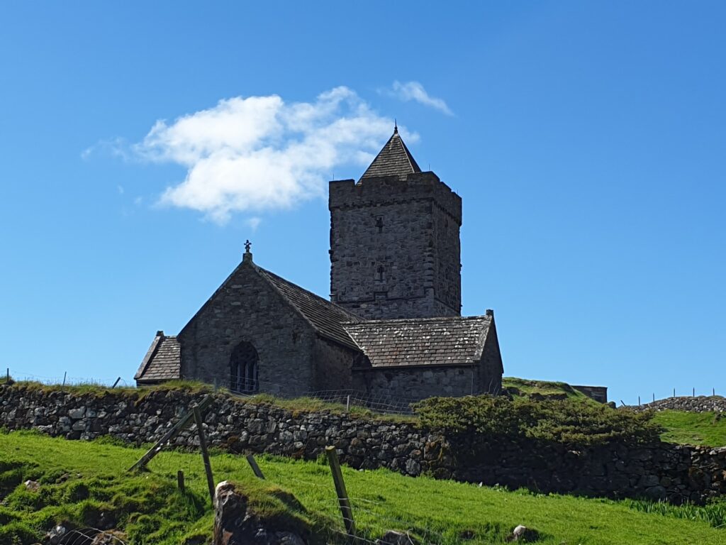
Roghadal is home to St Clement’s church, a much painted and photographed building that is more reminiscent of Cornwall than the Hebrides. It is a grey stone cruciform building with a tower and small pyramid spire. I haven’t seen anything remotely similar in these islands, and it is understandably a tourist draw. It stands a little above the small harbour at the bottom of a green valley, where the village, such as it is, briefly unfolds. In the sunshine it was all achingly pretty. Thee were a few tourists looking at the church. I was more intent on finding some food before my 2 hour ride back to Tarbert. There used to be a hotel here; but no more. The village was obviously once important and it is signed from about 25 miles away; but the only services on offer were the public conveniences by the church. I had 2 biscuits and some water with me; a schoolboy error. A cyclist needs fuel.
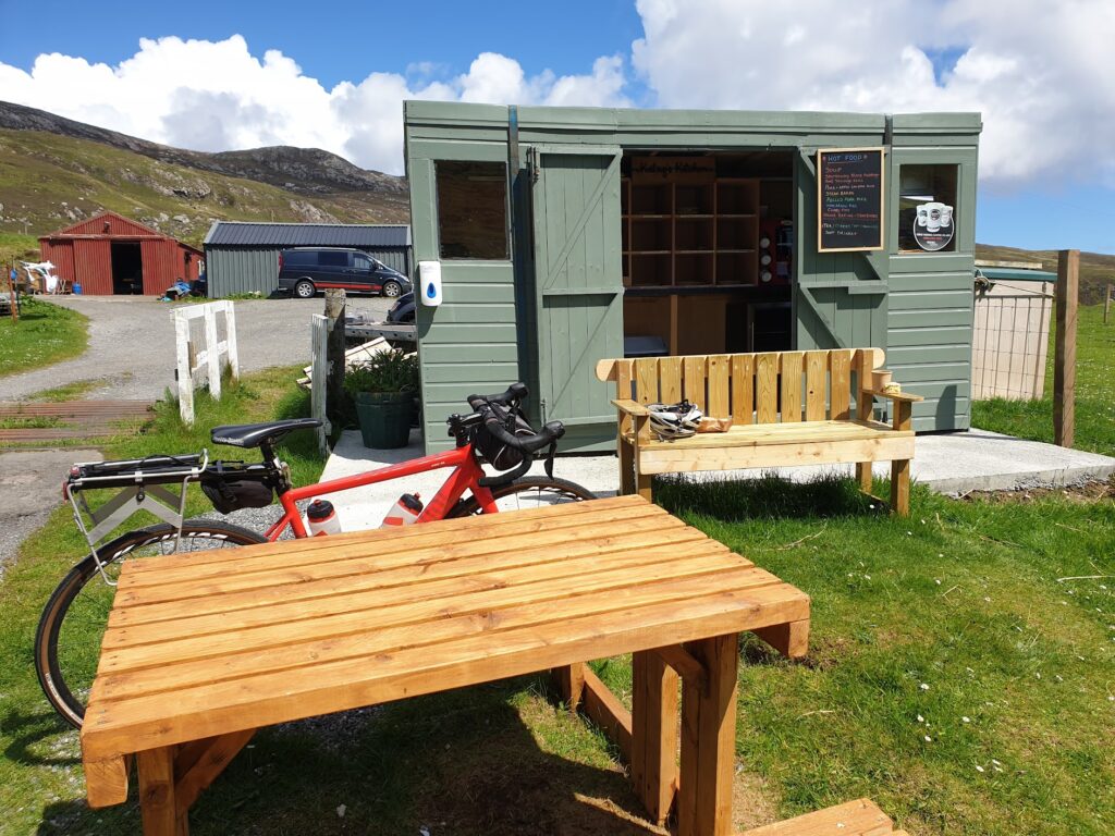
Looking up the green valley I thought I saw something fluttering by one of the far houses. Could it be a tea room or shop? It had to be worth a try. It turned out to be both, and neither. Katag’s Kitchen, as the flags advertised, was a small shed at the end of the driveway in which was assembled a delightful range of home made food. It was all done on an honesty basis. There was even a pot of hot soup, and some warm beef and black pudding sausage rolls. There were 2 small picnic tables to eat at and I could not have been more grateful or delighted. The food was delicious. I finished my meal with a slice of Smiddy Dumpling, a very moist fruit cake. Sometimes things are just meant to be.
Newly restored, I cycled the Golden Road back again. It was just as lovely going the other way. At the end, you have a stiff climb for a mile or so to the main road before it plunges down to Tarbert. This was the most rock strewn section of all. Apparently this area was used by Stanley Kubrick to stand in for Jupiter in 2001 A Space Odyssey. You can see why. It is other-worldly.
Back in Tarbert and reunited with my luggage, I was ready to let the bus do the rest of the day’s work and take me back to map 8 over the mountains. But where was it? The only vehicle waiting in the car park was minibus sized, not the coach that had easily accommodated my bike yesterday morning. I recognised the driver. My heart sank as he put up a Stornoway sign in his front window. So much for my careful planning. But not to worry. Even this cut down bus, with its single seats down one side, had room in the luggage area round the back for one bike. And that was all I needed. I had to pay twice the standard fare but I didn’t care. In an hour I was back in Stornoway and soon after that enjoying venison broth, before finding my bnb for the night.
Donald is my host, a lovely, chatty bloke who built the house we are in 6 years ago. The location is slightly raised, giving it a magnificent view out over the town to the sea and all the way tonight to the distant mountains of the north west mainland about 40 miles away. It’s quite an outlook. He says that land here is cheap, and I have seen lots of new looking houses. How different from most of the rest of the country, where quarter of an acre would be considered a luxury few can afford, or even find, for that matter. He also told me my fact of the day, which is that the Lewis and Harris chapter of the Glasgow Rangers Supporters club is the biggest in the world. Which seems pretty unlikely to me. But he has it on a mug, so it must be true!
Big day tomorrow. I’m planning to ride all the way through maps 15, 16 and 17 to the east coast. So I need some sleep!
4 replies on “Map 14 – The Golden Road”
I well remember the Golden Road from my Hebs trip in 2013. It was similar weather too! Good luck with the rain tomorrow…
Mark
What a fantastic initiative! I am sure many of us stuck at our desks are extremely jealous so well done for making the time.
I look forward to a daily read! And when you get to Map 100 I will be prepared with some high calorie baking.
Tim
I find it extraordinary that Google’s been down the Golden Road too! 🙂 looks fantastic.
Mark
What a fantastic journey to follow from the comfort of my desk. I will enjoy the updates.
When you get to map 100 I will be ready with some high calorie baked products!
Tim