
I don’t mind admitting that I rather enjoyed myself in OS Map 31. It was worth all the effort it took to get here and I am a little sad to be leaving already. The weather helped a bit. It was a dry, breezy sort of day and the visibility was good.
And I got to visit and enjoy no less than four different islands today: Eriskay, Barra, Vatersay and the bottom part of South Uist (my gateway to the mainland in Mallaig, and also where I am staying).
Each one offered something to remember it by. Each was a manageable size. All of them present a rugged, bare beauty; none of them ever removed me from the sight or the smell of the surrounding sea.
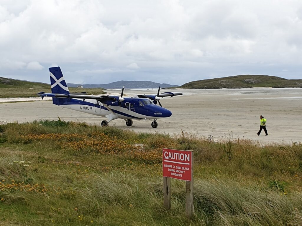
I cycled over the causeway to Eriskay in the morning to take the first ferry at 10.15am, and in 45 minutes I was on Barra. The boat arrives near the top of the island, close to one end of the huge, empty white sand bay that serves as its airport. In fact it is the only place in the world where scheduled flights take off and land on a tidal beach, making it not only a transport hub, but also a curiosity that attracts people like me.
As luck would have it, the flight from Glasgow came in a bit after 11am, just like I did, so I was rewarded with a close up view. The planes are tiny and probably seat less than 20 people. The airport terminal building is essentially a cafe with an extra counter for checking in. When the call came to board, people just got up and walked out onto the beach. Bizarre.
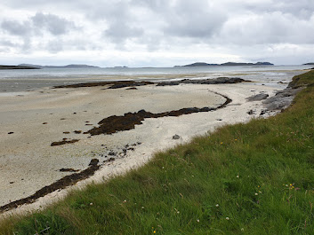
I had banked on the airport for some kind of breakfast but the cafe was closed. Instead I used their new talking vending machines to get a coffee and some chocolate. It helped. Then I rode to the very tip of the island at Eoligarry to gaze back over the Sound of Barra to South Uist and Eriskay, white beaches punctuating the rocky shore.
Everywhere I went the roads were small and quiet. The A888 is mostly single track as it makes a full circle of the main mountainous mass of the island.
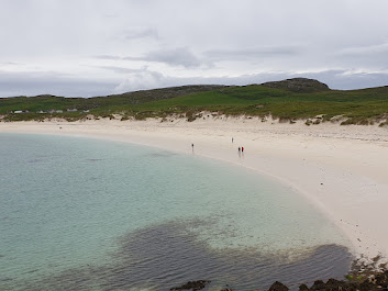
The west coast is a series of white sand bays, which are very pleasing to the eye. Above one of the whitest is the rather modern looking “Isle of Barra Beach Hotel”, which I knew to be Britain’s most westerly pub. I was still in search of breakfast – now brunch – and was disappointed to discover that they are not doing lunch this year!
But they were offering ”Tea by the Sea” and the view of the bay was fine indeed. So I took up the offer and enjoyed a very good pot of Earl Grey and a large piece of chocolate cake, which is not at all my usual midday snack; but was all they had. It filled a hole, though, and I could have easily moved on to beer in the very pleasant lounge that I had all to myself.
Except that I had another island still to go and a hard deadline to get the ferry back to Eriskay. Life can be tough at times.
Castlebay is the main village on Barra and has the only shops and other main services. It sits at about 6 o’clock on the loop of the A888 and is also where you turn south to cross another causeway over to the most southerly inhabited island in the Outer Hebrides, Vatersay. Here you can walk over the grassy dunes in a couple of minutes from a white sand beach facing the mainland to another that faces the Atlantic.
It all looked serene today, but a stone obelisk on the dunes commemorates the loss of the Annie Jane in September 1858, when three quarters of its 350 crew and passengers, emigrants bound for Canada from Liverpool, drowned in this bay.
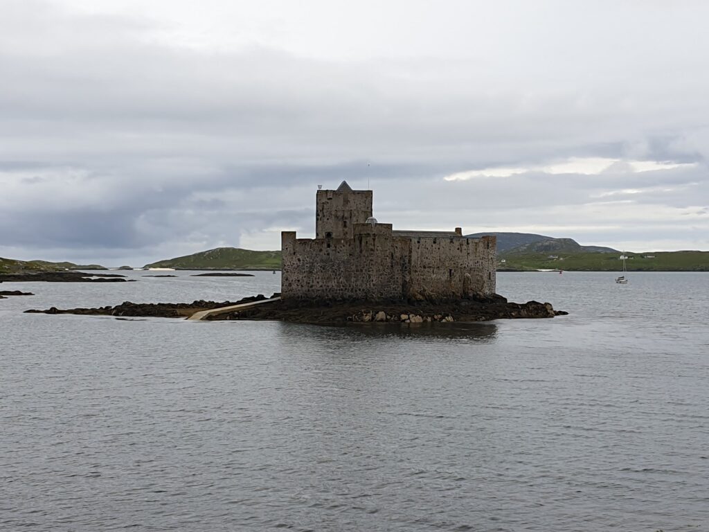
Vatersay provided a cafe serving warm, savoury food at last. When I left, I had just time to photograph Kisimul Castle, sitting prettily on an islet in the bay opposite Castlebay village. Then it was up the big hill and on, anti-clockwise, to complete the circle, and watch the ferry arrive to take me back to Eriskay. It was sunny enough to sit outside as we crossed, and even nice enough to sit outside at the pub in Eriskay, ”Am Politician”, for a beer.
Which was lucky because it was pretty full inside. I met a man from Helsinki who, it turned out, had been on the plane I saw land. He was looking for a place to camp, which – according to one of the local clientele – you can do anywhere on Eriskay.
The pub, which looks like a bungalow, is named after another boat that famously sank just off Eriskay. The S. S. Politician, bound for Jamaica from Liverpool, went down in a storm in February 1941, carrying, amongst other items, 250,000 bottles of whisky. Locals “liberated” an estimated 9,000 cases before the belated intervention of Her Majesty’s Customs and Excise.
The story – and film – Whisky Galore is loosely based on these events. On a shelf in the pub are 2 bottles, a pistol and a scythe-like knife, all reputedly salvaged from the wreck. The staff will get them down for you if you ask. My Finnish friend was most excited.
A local man, the retired postman as it turned out, was having dinner at the table next to me, with his extended family. They were shocked to hear of my breakfast troubles, apologising ”on behalf of the Outer Hebrides” at what they clearly felt was not good enough.
The meals in Am Politician went a long way to make up for it, however, and I returned over the causeway glad still to have a few miles to cycle off some of my succulent but frankly enormous steak pie.
I need to get the 5,45am ferry in the morning to Mallaig. God help me! I shall simply treat it as an interruption and aim to get in a further 3 hours of sleep on board (update: I did!). And then, for the last time, I will be visiting my old friend Skye again!
2 replies on “Map 31 – The only way is Eriskay”
Did you get a T-shirt?!
Love the castle and the aeroplane! Another good day 👍