
I did an amazing thing this evening. Between the hours of 8pm and 10pm, I cycled the A894 and the A838 from the small village of Scourie, at the western tip of OS map 9 Cape Wrath, to Durness, at the top of Scotland. It wasn’t an especially amazing cycling feat in itself. It took me an hour and 45 mins, including photo stops, to cover about 25 hilly miles. But the weather was calm, the scenery was utterly magnificent and I was utterly alone in it. I know I can’t do it justice in words, but my best effort will have to wait for the end of this account of today, so that our journey doesn’t lose its thread.
It began with the expected strong wind, and a sense of relief that we would not be fighting against it. Our host, Karen, chatted to us after breakfast about life in Lewis. She is from England and she married a Scot. They have lived in Lewis for 14 years. She spoke to us about the strict religious observance of Sunday in these parts. Until not too many years ago there was no ferry service and no flights on a Sunday. Childrens’ playgrounds were locked. No businesses would be open. Apparently some people wouldn’t even cook on a Sunday. “It’s getting better,” Karen said. “I feel OK hanging out my washing on a Sunday these days. If anyone asks, my attitude is that if the Lord sent a fine day for drying clothes, He meant it to be used!”
We flagged down the bus – a big coach – at the end of Karen’s drive and placed our bikes in the luggage compartment underneath. Last night’s cyclists from Sheffield were waiting outside the Cross Inn with 2 more bikes, also sensibly deterred by the high winds. There was plenty of space for all 4 bikes. This is potentially good news for my future trips out here for maps 13 and 14, possibly saving me unnecessary westward miles in the saddle. You learn as you go.
Back in Stornoway we had an hour to kill before boarding time for the afternoon ferry to Ullapool. We left our bikes at the ferry terminal along with 20 or so other cyclists, most of whom had sensibly ridden north up the Hebridean chain of islands, starting at the bottom with Barra, and island hopping their way here. I have done most of that excellent route before a couple of times and would recommend it. Now it seems to have an official title: “The Hebridean Way”. It is attracting cyclists of all ages from far and wide. In time, I will see all of the different islands again myself as I start each subsequent coast-to-coast leg of my OS map adventure; but a more vertically aligned map numbering system wound have been helpful!
We were worried about the potential for a rough crossing. Our Sheffield friends’ graphic description of their voyage over to Lewis caused us to bring forward lunch while the horizon was still in one place. We found a slightly posh cafe bar by the harbour and I had loaded fries for the second day in a row. Stornoway is a pleasant enough town without being picture postcard pretty. It enjoys a wonderfully sheltered natural harbour and has all the things you would expect the only town in the Hebrides to have. I thought it was at least trying to make something of itself. I’ll be back in a few days, and I’m OK with that.
In the event, the 2.5 hour crossing to Ullapool was as smooth as could be. I snoozed for an hour in the comfy seats of the warm, quiet observation lounge at the front of the boat. When I awoke, we were closing in on a coastline of glorious mountains of all shapes and sizes. As an approach to a ferry port, Ullapool would take some beating.
We got off the boat and back to our van after 5pm, slightly late and with plenty still ahead of us. Jenni drove the van north for about 40 mins until we reached an idyllic spot where you could walk out to the ruins of Ardvreck Castle, sitting on a small islet in Loch Assynt. A sign reminded visitors that this was a scheduled ancient monument and neither a campsite, nor a toilet, nor a climbing frame!
I drove us on to Scourie, the only place really worthy of the word village for many miles in any direction. Here we stopped for dinner at the delightful, if rather upscale, Whale’s Tail restaurant. We have got used now to booking ahead. Places are so few and far between that if you want to eat, you don’t take a chance. This was our good fortune this evening, because the food was sensational. A fitting last supper before Jenni leaves me tomorrow to head towards home. And so it was that I changed into my cycling clothes at 8pm comfortably full of a seaweed starter, followed by my favourite, rack of lamb, all locally sourced.
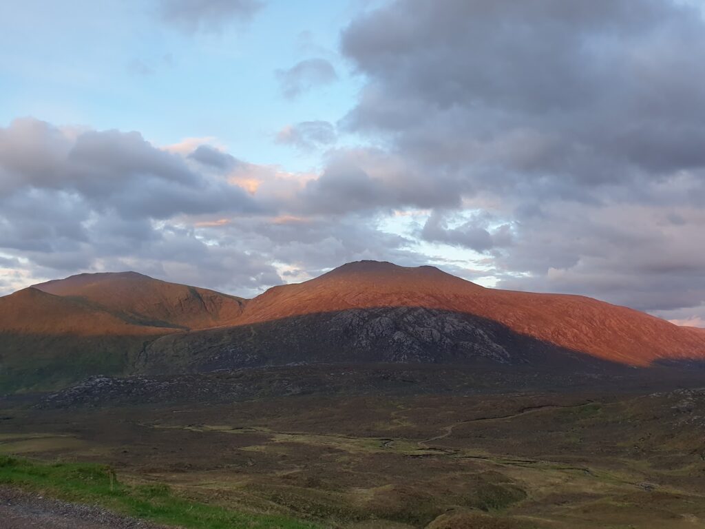
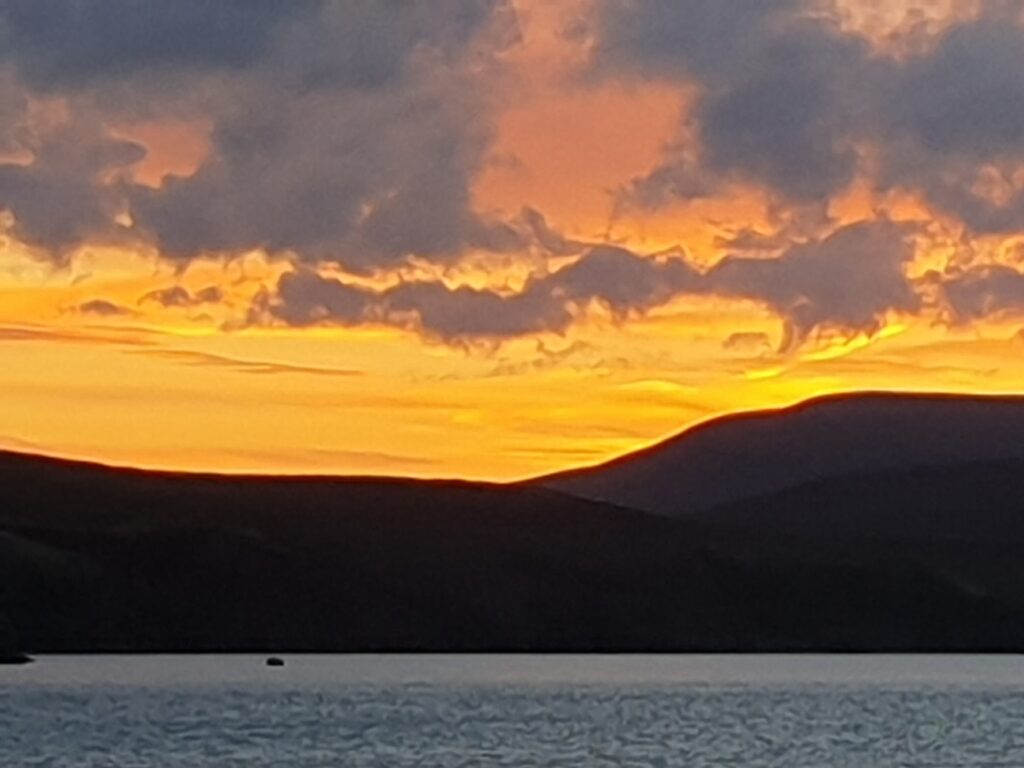
And then the fun really started. My crossing of Map 9 will be very hard to beat. I was treated to some of the finest mountain scenery I have seen, on an evening of enchanting light, when the official time for sunset was 9.50pm. The light got better as I went further, culminating in a splendid sunset over Cape Wrath. In between, over 25 miles, I had all this grandeur to myself. It makes you feel very small. I kept a count of cars that passed me, and also a count of the wild red deer I saw close by on the hillsides. Over 25 miles of A road, it was an honourable 6-6 draw between man and nature, with nature taking it on penalties with a late cuckoo calling across the Kyle of Durness. Along the way were mountains the shape of massive domes of bare rock, while another looked for all the world like the Lonely Mountain in The Hobbit. Later in the ride, I had a long, continuous downhill stretch of single track road to myself that lasted for about 7 miles, with hardly any need to pedal. All the time, the top of the mountain to my right glowed pink in the last rays of the setting sun. Pretty stunning stuff.
Sometimes cycling can transcend anything you experience in normal life. Tonight was one of those times.
2 replies on “Map 9 – The Road to the Top”
Sounds chuffin’ wonderful Mark!
Sounds idyllic- especially the 6 all draw ! Nice to hear there’s plenty of other cyclists around too.